NEMRUT DAGI IN TURKEY
X introduction X
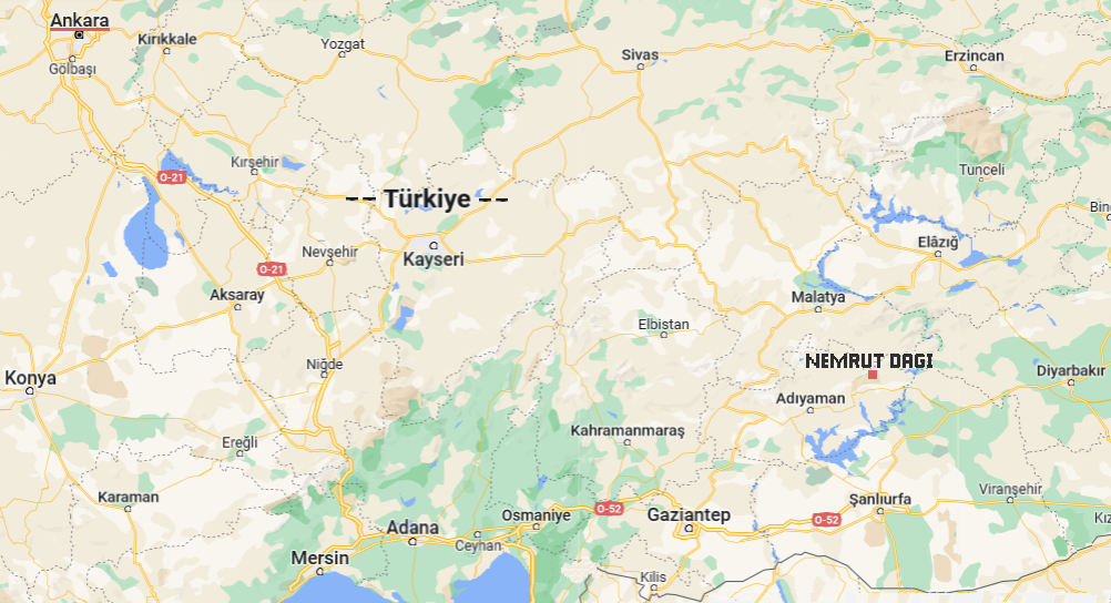
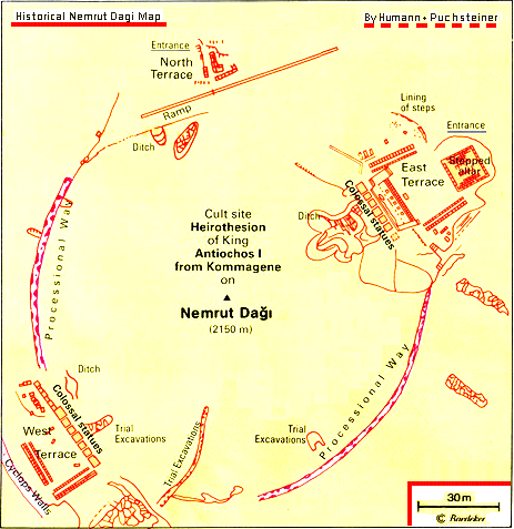
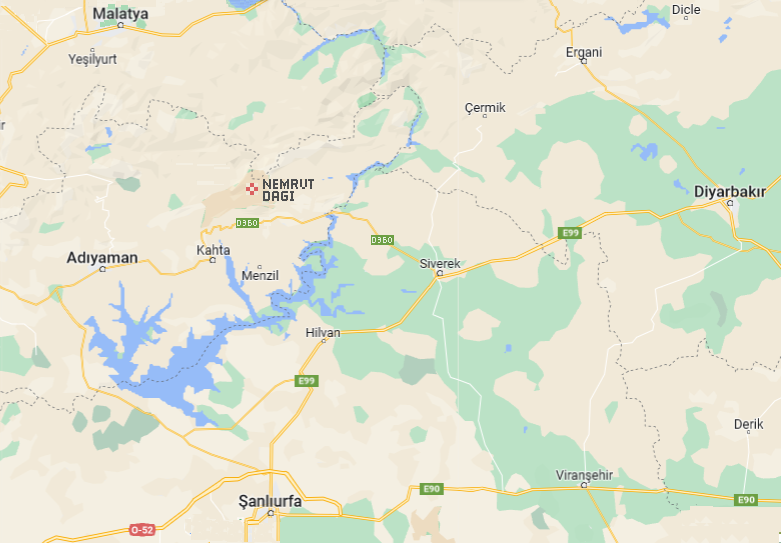
nemrut dagi is a high mountain, 2134 m, in east turkey, south-east of malatya, north-east of adiyaman - see the following map.
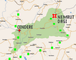
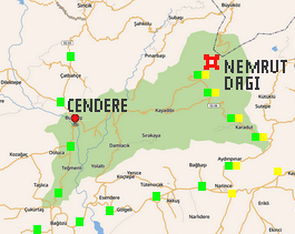
on the top of this mountain – which is not easy to reach - are several unique, and very famous, historic monuments. this area is now a national park. the separate historic area of cendere belongs to it, it is located in the north-west sector.
prescriptum:
in the introduction to my ‘picture galleries travels countries’ i state “i don't want to be too formal & 'educational', so there aren't full descriptions, nor even figure captions, just a few eclectic remarks about the things shown”
however - this concept is not maintained for the nemrut dagi gallery! rather, it contains lot of information about history & art, and travel features as well.
X nemrut dagi architecture X
>>> main views
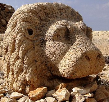
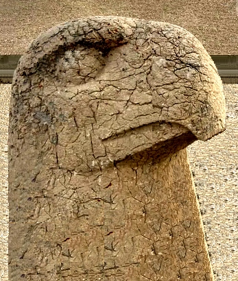
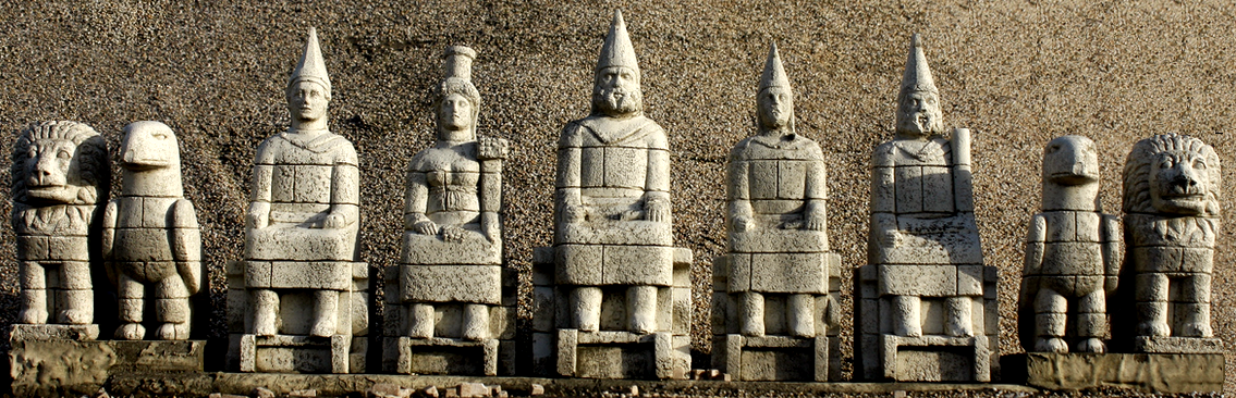
after reaching nemrut dagi, one sees the summit of the mountain consisting of countless stones, and i front of it a very large built monument. it consists of 7 enormous figures – yet all the heads are missing. these are placed in front of the monument’s lower rampart, or elsewhere. this whole view is stunning, almost hard to believe.
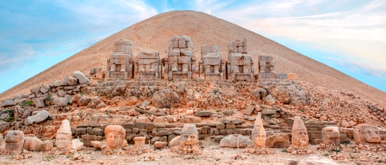
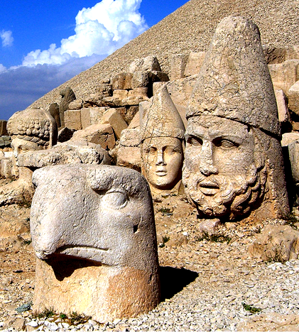
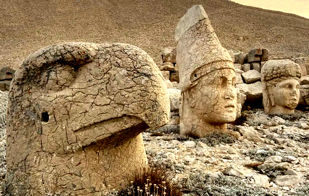
>>> fallen heads
after 2000 years, they do not look new – most many are in reasonably good shape, in spite of the frequent rain, and even frost and snow up there.
the figures are meant to represent either gods or the rulers. there are also two kinds of animals, lions and eagles.
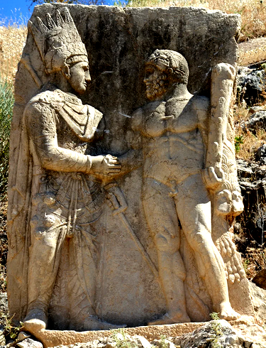
>>> meetings
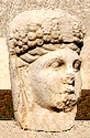
nearby are several steles which show the king of commagene, in persian dress, shaking hand with a god or (on this stela) with herakles. they shall express respect and hospitality.
in 1997 the whole monument was declared by unesco as a world cultural heritage site.
X the nemrut dagi archaeology X
the phenomenal monument on the nemrut dagi mountain had actually been forgotten for possibly a thousant years, partly of its remote location, partly because of no cultural link to the ottomans or the current turkey.
it was in 1881 (!) that the german engineer, karl sester, who explored for the ottoman empire transportation options in eastern turkey, heard by chance of the historic buildings on nemrut dagi, together with a kurdish guy he climbed up there – and was overwhelmed by what he saw.
here is, briefly, what then happened:
1882 the german archaeological center sends otto puchstein together with sester
1883 puchstein returns with karl humann to the nemrut dagi
1883 a turkish team, hamdi bey and osgan effendi, also goes there
1890 detailed report about the german research by humann & puchsteiner publicated
in this early research, conducted in rough condititions, thorough excavations were not yet possible. much later:
1939 friedrich karl doerner from germany re-activates research at nemrut dagi
1946 doerner returns after ww-2, now able of advanced technology
1955 wide international research starts.
one of the most determined, yet also weirdest -us-american researchers was theresa goell. she visited nemrut dagi first time in 1947 (unusual in a male-dominated context), and the monuments there became her focus until her death in 1985. yet unfortunately she never completed her reports.
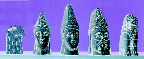
below are two thorough sketches of conclusions from the first research efforts, published in 1890, both still valid.
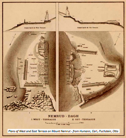
only recently (2023) the english “the connection team” has published their attempt to design models of all statues, peoples and animals, as they were originally.
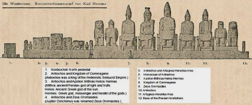
the much older graph by karl humann (1890) allocates the at that time assumed peoples or animals, especially gods.
X the commagene kingdom X
well, it’s time now to outline what and who was behind the enormous monuments on the nemrut dagi mountain.
it was the short-lived small kingdom named “commagene”. that name is assumed to go back to a greek notation. this rather little and instable state had a size roughly like the australian states tasmania or victoria.
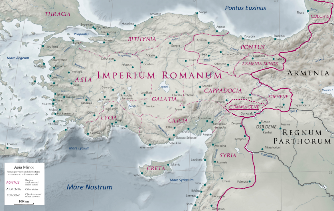
the map shows that commagene was kind of a buffer between the roman empire and armenia and partia. culturally it is rated as a greco-iranian kingdom, ruled by a hellenized branch of an iranian dynasty. the kingdom sophene may have been linked to commagene. its capital city was samosata.
what’s known about commagene’s history:
163 b.c. - 16 a.d.: first period of c. as an independent country, “syro-hittite” by nature
17 a.d.: roman emperor tiberius makes a roman province
38 a.d. – 71 a.d.: second & final period of c. as an independent country
38 a.d.: regaining independence, under king antiochus-1-theos
72 a.d.: after antiochus’s death, emperor vespasian makes it part of the roman emprire
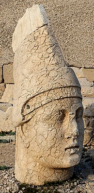
king antiochus-1 was by heritage half greek and half persian/iranian. he set up a royal cult for himself, preparing to be worshipped after his death.
in consequence, he created the monuments on the “holy” mountan nemrut dagi as his sanctuary. note: one of the pictures above actually presents him, here is a reprint:
solid information about how this huge facility could be built so far away from cities and so high up seems to be missing. it is known though that religious festivities occurred regularly, and that special priests conducted them.
finally – is king antiochus actually buried there? in spite of very intense research, nothing was found, so the location of the tomb of king antiochus remains a puzzle. some investigators believe that he was not here buried, that his grave may be elsewhere. which means, not what he did, but where he “is” now remains a mystery
X how to get to nemrut dagi X
it was 1977 that i travelled to nemrut dagi – i had read about it and was determined to see it. yet at that time roads in eastern turkey were rough, and my car, a peugeot-404, did not have 4-wheel drive.
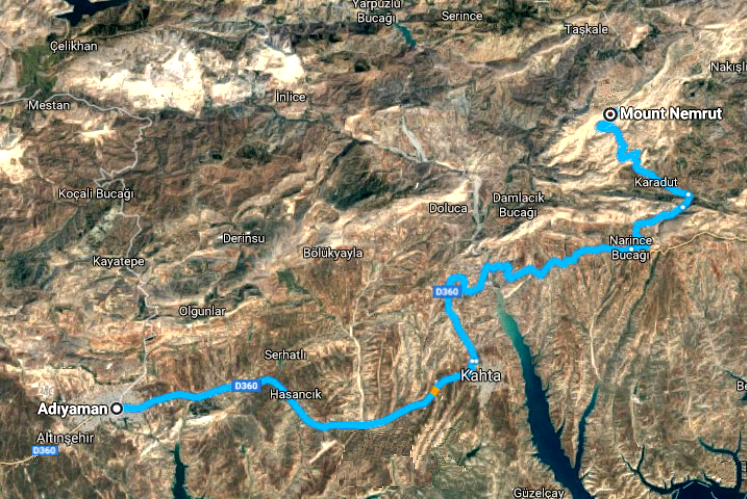
of the tracks leading to the the monument on top of nemrut dagi in 2100 m height, only one was suitable for cars, the other ones were for hikers.
the above map shows this track, and, with green markers, the pathways for travellers coming from north (malatiya) or west (adiyaman).
what was my way? unfortunately my travel diary from 1977 has gone lost. i believe though that my route was the one from diyarbakir, from east, because this stunning city i had visited on my turkey exploration, after the excursion to erzurum. for this yellow markers are shown.
nowadays turkey has established a well-designed road to reach (almost) the peak of nemrut dagi. meanwhile several bus and taxi enterprises offer convenient trips from adiyamen.
this means, nemrut dagi is now far easier to reach than for me in 1977.
X buildings in cendere X
the second historic building in the nemrut dagi national park is a bridge. around the year 200 the roman empire, under emperor septimius severus, built a strong ‘one-bow’ bridge over the river cendere. length: 120 m, width: 7 m, height: 34 m.
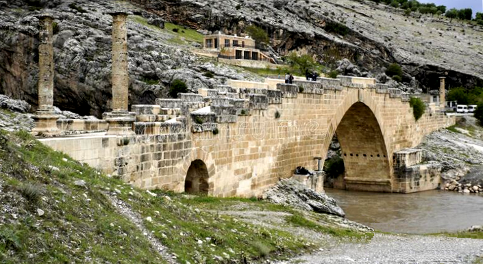
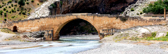
the four columns at the bridge are allocated to septimius severus, his wife and their two sons. the building is not used for traffic anymore yet can be visited by pedestrians.
X the end of this gallery X
so - it is worthwhile to go on the long and rather rough track to visit nemrut dagi? certainly not for any kind of ‘easy-going’ people.
yet - - what you can see there on this high mountain is truly unique, and, in spite of many fallen-apart features, gives you a still vivid experience of a ‘super-monument’ designed and built 2000 years ago in a very remote place. furthermore, nowadays you can visit it at day or at night, and thereby catch rather different views!